Wednesday, April 02, 2008
Southport
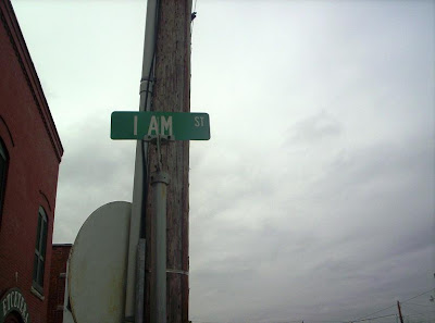
| You'll need this map to keep up with this post: View Larger Map After lunch we had over an hour to kill before our walking historic/ghost tour, so we decided to stroll around town. Right beside the Ship's Chandler was a parking lot and a small part with swings overlooking the ocean. on one end of the park was this monument:   Also on the display is Prices Creek which actually DOES have a lighthouse, but it's in sad shape and also on private property so you can't visit. There was one trip a few years back and you can read about it here. Like I said in my last post, the definition of "lighthouse" can be vague. That's why I plan to stick with the classic seven I listed previously. While on our walkabout, my mother noticed this rather odd street sign:   Use the map above again and zoom in close on the starting point. The main north south street in Southport is Howe Street. West is Lord St. East you'll find I Am St. (You need to zoom in some.) And then if you look just north you'll find Dry Street. These streets were named specifically to write out: Yeah, Southport folks are a bit odd.   |
Comments:
<< Home
Hi Jason, I found your blog article on Southport while doing a little surfing. I thought you might be interested in what I do also. I live in Holden Beach and do a lot of videos around Southport. The Trolley Stop is one of my favorite lunch stops. You can see my video sites here.
http://surf.dsrealty.tv
http://brunswickprofiles.com
Post a Comment
http://surf.dsrealty.tv
http://brunswickprofiles.com
<< Home


