You'll need this map to keep up with this post:
View Larger MapOnce we had finished our tour of the Oak Island Lighthouse, we loaded back on the bus for the short trip around to Southport. Since it was roughly lunch time, my mother and I opted for lunch at The Ship's Chandler. (This place has obviously been around for ever but seems to have changed names a lot.) The special for the day was the Cajun catfish. I found it funny that, so close to the ocean, they would be serving fresh water fish. But either way it was quite delicious. (And with that I knew a few people's jaws dropped at hearing I ate fish.)
After lunch we had over an hour to kill before our walking historic/ghost tour, so we decided to stroll around town. Right beside the Ship's Chandler was a parking lot and a small part with swings overlooking the ocean. on one end of the park was this monument: This left me quiet confused for a while. Eventually I figured out the problem. Everything is upside down. The top of the display is SOUTH the bottom of the display is NORTH. Southport is on the southern side of the island. The reason this was drawn this way was help identify what you see when you look up. (Use the map above to orient yourself.) This left me quiet confused for a while. Eventually I figured out the problem. Everything is upside down. The top of the display is SOUTH the bottom of the display is NORTH. Southport is on the southern side of the island. The reason this was drawn this way was help identify what you see when you look up. (Use the map above to orient yourself.) This is looking to the right to Oak Island Lighthouse, where we had just been. Straight you could barely see Old Baldy in the distance. None of my pictures really turned out. You may notice the display mentioned a "Battery Island Lighthouse." There is no such thing that I know of. Battery Island is famous for being a huge migratory and marsh bird sanctuary. Apparently the right time of year the island is covered with nesting marsh birds. Humans aren't allowed on the island, so unless there's an ibis working as light keeper, I suspect the "lighthouse" is the remains of an old structure. This is looking to the right to Oak Island Lighthouse, where we had just been. Straight you could barely see Old Baldy in the distance. None of my pictures really turned out. You may notice the display mentioned a "Battery Island Lighthouse." There is no such thing that I know of. Battery Island is famous for being a huge migratory and marsh bird sanctuary. Apparently the right time of year the island is covered with nesting marsh birds. Humans aren't allowed on the island, so unless there's an ibis working as light keeper, I suspect the "lighthouse" is the remains of an old structure.
Also on the display is Prices Creek which actually DOES have a lighthouse, but it's in sad shape and also on private property so you can't visit. There was one trip a few years back and you can read about it here. Like I said in my last post, the definition of "lighthouse" can be vague. That's why I plan to stick with the classic seven I listed previously.
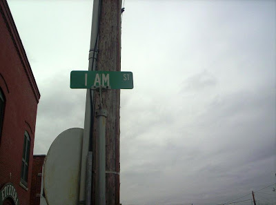
While on our walkabout, my mother noticed this rather odd street sign: We both remarked that there must be a good story behind it. I've been told repeatedly that the folks in Southport can be a bit odd at times, so I couldn't imagine what the story might be. Luckily we didn't have to wait long. We both remarked that there must be a good story behind it. I've been told repeatedly that the folks in Southport can be a bit odd at times, so I couldn't imagine what the story might be. Luckily we didn't have to wait long. While on our walking tour of Southport, our guide (in complete period clothing) gave the background. While on our walking tour of Southport, our guide (in complete period clothing) gave the background.
Use the map above again and zoom in close on the starting point.
The main north south street in Southport is Howe Street. West is Lord St. East you'll find I Am St. (You need to zoom in some.) And then if you look just north you'll find Dry Street.
These streets were named specifically to write out:"Lord, Howe Dry I Am."
Yeah, Southport folks are a bit odd.The one feature that dominates the island, though are the oak trees. Oak Island didn't get its name on a whim. The trees grow for decades and are loved and protected by the residents. However, like all trees and shrubs in coastal areas, the elements really do a number on them.
 |


Hi Jason, I found your blog article on Southport while doing a little surfing. I thought you might be interested in what I do also. I live in Holden Beach and do a lot of videos around Southport. The Trolley Stop is one of my favorite lunch stops. You can see my video sites here.
ReplyDeletehttp://surf.dsrealty.tv
http://brunswickprofiles.com